| TMS: 025-00-07-007 Owner Information:
Owner Occupied Property: No Homestead Exempt (Age 65+ or Disability): No | Council District: C7 Fire District: F02 Tax District: T04 TIS Zone: 4 Jurisdiction: 1P Acres: 0.00 Lots: 1.0 |
Neighborhood: D020 - RUSSELLVLE/41 SEC/HARRISTOWN/WEST OF ST STEPHEN Appraiser ID: DD Lot: Block: Section: Zoning: Berkeley County - Flex1 Parent TMS: Notes:ADD TO RES REMOVE DRAWINGS PARCEL 06/92 RESMT 6/98 RESMT 2004-CHANGE CLASS OF RES AND DEP 4/03 JB SEP 0.10 AC FROM 025-00-07-007 (NOW 0.91 AC RESIDUAL) TO BE COMB WITH 025-00-07-049 (NOW 1.06 AC) PER PLAT REC CAB Q-202K AND PER DEED 2708/423 |
| Site addresses: | |||||||||||||||||||||||||||||||||||||||||||||||||||||||||||||||||||||||||||||||||||||||||||||||||||||||||||||||||||||||||||||||||||||||||||||||||||||||||||||||||||||||||||||||||||||||||||||||||||||||||
|---|---|---|---|---|---|---|---|---|---|---|---|---|---|---|---|---|---|---|---|---|---|---|---|---|---|---|---|---|---|---|---|---|---|---|---|---|---|---|---|---|---|---|---|---|---|---|---|---|---|---|---|---|---|---|---|---|---|---|---|---|---|---|---|---|---|---|---|---|---|---|---|---|---|---|---|---|---|---|---|---|---|---|---|---|---|---|---|---|---|---|---|---|---|---|---|---|---|---|---|---|---|---|---|---|---|---|---|---|---|---|---|---|---|---|---|---|---|---|---|---|---|---|---|---|---|---|---|---|---|---|---|---|---|---|---|---|---|---|---|---|---|---|---|---|---|---|---|---|---|---|---|---|---|---|---|---|---|---|---|---|---|---|---|---|---|---|---|---|---|---|---|---|---|---|---|---|---|---|---|---|---|---|---|---|---|---|---|---|---|---|---|---|---|---|---|---|---|---|---|---|---|
| 152 ROSALEE LN ST STEPHEN, SC 29479, Unit/Lot: | 154 ROSALEE LN ST STEPHEN, SC 29479, Unit/Lot: | ||||||||||||||||||||||||||||||||||||||||||||||||||||||||||||||||||||||||||||||||||||||||||||||||||||||||||||||||||||||||||||||||||||||||||||||||||||||||||||||||||||||||||||||||||||||||||||||||||||||||
| Owner: MIDDLETON ORA D | Sale Date: 04/26/2000 | Sale Price: $5.00 | Deed Book-Page: 1919 - 0118 | Plat: S - 181 | Transfer Notes: 1.00 Acres Recorded on Plat S - 181 |
| Owner: MIDDLETON ORA D | Sale Date: 04/26/2000 | Sale Price: $5.00 | Deed Book-Page: 1919 - 0118 | Plat: S - 181 | Transfer Notes: PLAT CAB Q-202K (0.91 AC RES) 4/18 |
| Owner: ROSA LEE DAVIS | Sale Date: 05/16/1988 | Sale Price: $5.00 | Deed Book-Page: A755 - 0287 | Plat: S - 181 | Transfer Notes: 1.00 Acres Recorded on Plat S - 181 |
| Owner: DAVIS ROSA LEE INT | Sale Date: 05/19/1981 | Sale Price: $5.00 | Deed Book-Page: A431 - 0186 | Plat: S - 181 | Transfer Notes: 1.00 Acres Recorded on Plat S - 181 |
| Owner: DAVIS ORA & EDNA MAE INT | Sale Date: 05/18/1981 | Sale Price: $5.00 | Deed Book-Page: A430 - 0343 | Plat: S - 181 | Transfer Notes: 1.00 Acres Recorded on Plat S - 181 |
| Owner: EADIE ALFRED N ETAL | Sale Date: 08/13/1969 | Sale Price: $200.00 | Deed Book-Page: A202 - 0095 | Plat: S - 181 | Transfer Notes: 1.00 Acres Recorded on Plat S - 181 |
| Tax Year | Receipt # | Tax District | Original Total | Total With Penalties (if applicable) | Pay Date | Pay Type | Delinquent | Taxed Value | Owner Occupied (4% QR Rate) |
|---|---|---|---|---|---|---|---|---|---|
| 2023 | 0117954 | 4 | $487.91 | $542.46 | Unpaid | Yes | $20,400 | No | |
| 2022 | 0107540 | 4 | $500.20 | $547.33 | 08/04/2023 | Paid | Yes | $20,400 | No |
| 2021 | 0103455 | 4 | $502.79 | $695.31 | 10/24/2022 | Landsale | Yes | $20,400 | No |
| 2020 | 0107066 | 4 | $504.12 | $601.84 | 06/25/2021 | Paid | Yes | $20,400 | No |
| 2019 | 0104657 | 4 | $503.39 | $556.00 | 06/04/2020 | Paid | Yes | $20,400 | No |
| 2018 | 0102220 | 4 | $682.35 | $709.39 | 03/01/2019 | Paid | No | $27,600 | Yes |
| 2017 | 0099839 | 4 | $939.02 | $997.52 | 03/16/2018 | Paid | No | $47,300 | Yes |
| 2016 | 0097587 | 4 | $944.78 | $1,153.40 | 10/23/2017 | Landsale | Yes | $47,900 | Yes |
| 2015 | 0096730 | 4 | $915.01 | $999.16 | 04/06/2016 | Paid | Yes | $48,600 | Yes |
| 2014 | 0095232 | 4 | $867.23 | $1,065.71 | 11/16/2015 | Landsale | Yes | $48,600 | Yes |
| 2013 | 0093850 | 4 | $742.87 | $810.80 | 11/05/2014 | Paid | Yes | $54,700 | Yes |
| Last Sale Date: 04/26/2000 Recording Date: 05/03/2000 Sale Price: $5.00 | Plat Information: S - 181 Deed Book: 1919 Deed Page: 0118 | Sales Validity: 2 Validity Other: |
| Building Market: 11,400 Land Market: 9,000 | Building Taxable (4% Res): 0 Building Taxable (6% Other): 11,400 Building Taxable (4% Ag): 0 Building Taxable (6% Ag): 0 | Land Taxable (4% Res): 0 Land Taxable (6% Other): 9,000 Land Taxable (4% Ag): 0 Land Taxable (6% Ag): 0 |
| Total Taxable Value: 20,400 Total Assessment: 1,220 | ||
| Fee Name | Fee Amount |
|---|---|
| Fire Fee | 80 |
| Land Fill Fee | 75 |
| Stormwater Utility Fee | 36 |
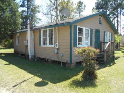
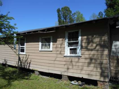
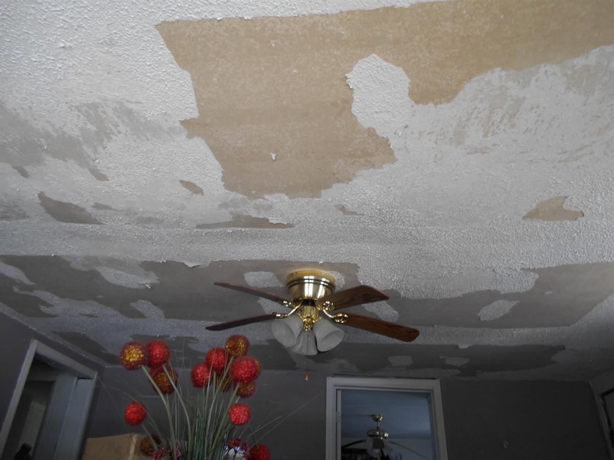
| Building Count: 1 Residence Count: 0 | Yard Item Count: 0 Mobile Homes on Property: 1 |
| Sub Area | Sub Area Description | Sketched Area (SqFt) |
|---|---|---|
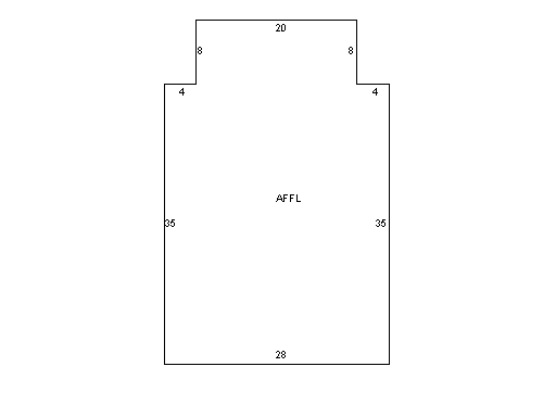
| AFFL | 1st Floor | 1140.0 |
| Building Total Finished SQFT: 1140.0 | ||
| Decal # | Owner Name | Street Address | Storage? | Year Built | Dimensions |
|---|---|---|---|---|---|
| 21418C | WHITE VIRGINIA D | 152 ROSALEE LANEE | N | 1992 | 54x24 |